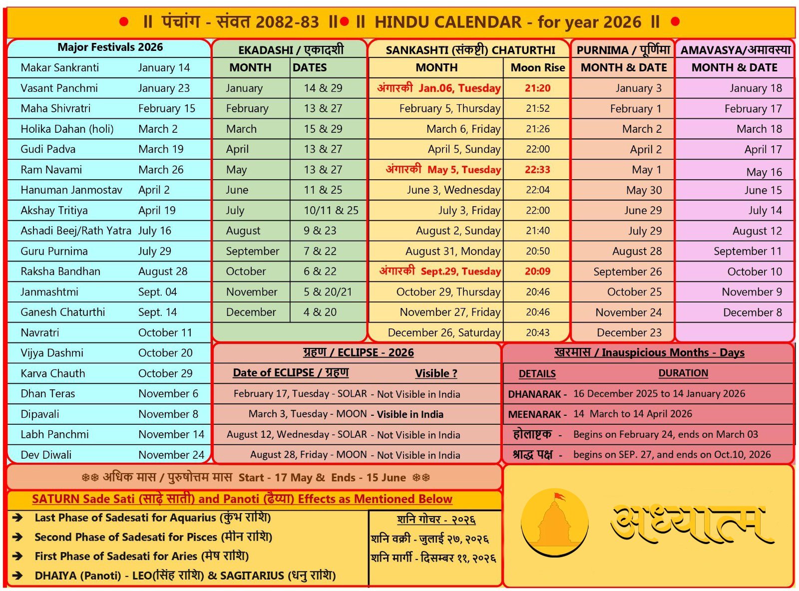


World’s first geography book – Shri Vishnu Purana.
The complete written description of the Earth is first seen in Vishnu Purana… The author of Vishnu Purana is… the great sage Parashar…
Rishi Parashar was the grandson of Maharishi Vashishtha, founder of Gotra, seer and writer of Vedic hymns… He was born from Shakti, the son of Vashishtha who was killed by a demon. After growing up, when he came to know about his father’s death from his mother Vishwaanti, he started a yagya called Rakshasatra for the destruction of demons, in which many innocent demons started getting killed. Seeing this, sages like Pulastya gave advice and freed them from the destruction of demons and gave them the boon of being the spokesperson of the Puranas. After this he composed Vishnu Purana…
This Purana is very important and ancient. In this Purana, there is a detailed description of the size of the sky etc., the size of the ocean, the sun etc., the mountains, the origin of the gods, Manvantar, Kalpa-division, the entire religion and the character of Devarshis and Rajrishis.
Shri Vishnu Purana has a very high place among the Ashtadash Mahapuranas. In this, along with other subjects, many subjects like geography, astrology, rituals, dynasty and Shri Krishna’s character etc. have been described in a very unique and detailed manner.
Here Lord Krishna himself, expressing his identity with Mahadevji, says to Shrimukh-
“tvaya yadabhayam dattam taddattamakhilam maya.
Matto’vibhinnamatmanam drushtumharsi shankar.
Yo’ham sa tvam jagacchedam sadevasurmanusham.
Matto naanyadshesham yatattvam jyatumiharhasi.
Avidyamohitatmanah purusha bhinnadarshinah.
Vandati bhedam pashyanti chavayorantam har.”
Currently seven thousand verses are available in this Purana. In many texts its number of verses is said to be twenty-three thousand. Vishnu Purana describes the five characteristics or subjects of the Puranas – Sarga, Pratisarga, Vansh, Manvantara and Vanshanucharit. All subjects have been mentioned proportionately. In between, light has also been thrown on spiritual discussion, good deeds and good conduct etc.
These are described in the following sections-
1. pre-part-first part
2. Pre-Part II
3. pre part-third part
4. Part IV
5. former part-fifth part
6. former part-sixth part
7. north part
Here I do not even want to give a brief description of all the parts… because the article is likely to become very long… but according to the subject matter of the article, I would like to introduce its “Part One – Part Two”. ..In this part, Sage Parashar has given a detailed description of the earth’s islands, continents, seas, mountains, and the entire landmass of the earth…
Rishi Parashar ji is giving this description to Shri Maitreya Rishi in Vishnu Purana. According to him, this cannot be described even in a thousand years. This is only a very brief description. From this we can get an idea of its greatness and comprehensiveness…
Those people who read and listen to Vishnu Purana with devotion and respect, both of them go to Vishnuloka after enjoying the desired pleasures here.
According to Rishi Parashar, this earth is divided into seven continents… (Even in modern times it is divided into 7 continents i.e. – Asia, Africa, North America, South America, Antarctica, Europe, and Australia)
According to Rishi Parashar, the names of these continents are –
1. Jambudweep
2. Plakshadweep
3. Shamaldweep
4. Kushdweep
5. Kraunchadweep
6. Shakadweep
7. Pushkardweep
These seven islands are surrounded by salt water, different types of liquids and fresh water seas respectively. All these islands are built one after the other, and are surrounded by seven seas. Jambudweep is situated in the middle of all these.
Of these, the most detailed description of Jambudweep is found… our country India is situated in it…
Jambudweep is situated in the middle of all the islands. The golden Sumeru mountain is situated in the middle of this island. Its height is eighty-four thousand yojanas and on many sides it is embedded sixteen thousand yojanas deep inside the earth. Its expanse is thirty-two thousand yojanas in the upper part, and only sixteen thousand yojanas in the foothills below. In this way, this mountain is like the ear of the earth in the form of a lotus.
To the south of Sumeru, there are Varsha mountains named Himavan, Hemkoot and Nishadha, which divide different years. To the north of Sumeru are the Neel, Shwet and Shringi Varshar Mountains. Among these, Nishadha and Neel are spread over one lakh yojanas. Hemkut and the White Mountains are spread over ninety ninety thousand yojanas. Himavan and Shringi are spread over eighty eighty thousand yojanas.
South of Mount Meru, the first year is called Bharatvarsha, the second is Kimpurushvarsha and the third is Harivarsha. To its south is Ramikavarsha, Hiranyamayavarsha and the third is Uttarkuruvarsha. Due to crossing the border of Uttarkuruvarsha archipelago, it is arched like India.
The expansion of all these is nine thousand yojanas per year. In the middle of all this is Ilavritvarsha, which is spread nine thousand yojanas around Mount Sumeru. And around it there are four mountains, which are divine nails, which hold Sumeru,
All these mountains are as follows:-
Mandarachal in the East
Gandhamadan in the south
abundant in the west
good side in the north
All these are ten thousand yojanas high. On these mountains, there are Kadamba, Jambu, Peepal and Banyan trees like flags respectively. Due to the Jambu tree being the largest among them, this island is named Jambudweep. A river named Jambu Nad flows from here. Drinking its water does not cause old age or loss of senses. When the soil of its minaret gets mixed with the juice, it turns into gold called Jambunad and becomes the ornament of the siddhapurushas.
To the east of Mount Meru is Bhadrashvavarsha, and to the west is Ketumalavarsha. In between these two is Ilavritvarsha. Thus, there are forests named Chaitrarath towards the east, Gandhamadan towards the south, Vaibhraj towards the west and Nandan towards the north. And Arunod, Mahabhadra, Asitod and Manas – these are the four lakes which are always consumed by the gods.
east of meru
winter,
Kumud,
curry,
valuable,
There are mountains like Vaivank etc.
south of meru
Trikuta,
Shishir,
Kite,
interesting
And there are mountains like Nishad etc.
north of meru
Shankhakoot,
Rishabh,
Swan,
snake
And there are Kalanj mountains.
India is situated north of the sea and south of the Himalayas. Its expansion is nine thousand yojanas. This heaven is the land of work which leads to attaining inferiority. It has seven Kulparvatas: Mahendra, Malay, Sahya, Shuktiman, Riksha, Vindhya and Pariyatra.
Bharatvarsha has nine parts:
Indradweep,
Kaseru,
copper foil,
pregnant,
Nagdweep,
gentle,
Gandharva
And Varun, and this island surrounded by the sea is the ninth among them.
This island is Sahasra Yojana from north to south. Here people of all four castes live in the middle. Rivers like Shatdru and Chandrabhaga etc. originate from the Himalayas, Veda and Smriti etc. from Pariatra, Narmada and Sursa etc. from Vindhyachal, Tapi, Payoshni and Nirvindhya etc. from Rikshyagiri. From Godavari, Bhimrathi, Krishnaveni, Sahya Parvat; Kritamala and Tamraparni etc. rivers originate from Malayachal, Trisama and Aryakulya etc. from Mahendragiri and Rishikulya and Kumari etc. rivers originate from Shuktiman mountain. They have thousands more branches and tributaries.
On the banks of these rivers, the countries of Kuru, Panchal, Madhya etc. Of the former country and Kamrup; Pundra, Kalinga, Magadha and Dakshinatya people, Aparantadesh residents, Saurashtra people, Taha Shur, Abhir and Arbud people, Karush, Malava and Pariatra residents; Sauvir, Sandhav, Hun; Shalva, residents of Kosal country and Madra, Aaram, Ambashtha and Parsi tribes live here. There are all four eras in India only, not anywhere else. This Jambudweep is surrounded from all sides by a ring-shaped sea of salt water measuring lakhs of yojanas. The expanse of Jambudweep is one lakh yojanas.
Description of Plakshadweep –
The expanse of Plakshadweep is twice that of Jambudweep. There is a huge Plaksa tree planted in the middle here. The owner of this place, Medhatithi, had seven sons. these were:
peaceful,
Shishir,
sukhodaya,
Pleasure,
Shiva,
Kshemak,
Dhruv.
Here, like Bharatvarsha, this island was divided into seven parts among seven sons, which were named after them: Shantahayvarsha, etc.
There are seven mountains that determine their limits:
onyx,
moon,
Narad,
Dundubhi,
Somak,
sumana
And Vaibhraj.
The only seven sea-going rivers of these years are Anuttapta, Shikhi, Vipasha, Tridiva, Aklama, Amrita and Sukrita. Apart from these, there are thousands of small mountains and rivers. There is neither growth nor decline in these people. It always remains the same as Tretayuga. Here the four castes are Aryak, Kurur, Vidishya and Bhavi, Brahmin, Kshatriya, Vaishya and Shudra respectively. Here there is a Plaksa (Pakad) tree of the size of the Jambu tree. This island is named after this.
Plakshadweep is surrounded by an ocean of Ikshuras of its own size.
Description of Shalmal Island
The owner of this island was Veeravar Vapushman. His seven sons:
white,
green,
jimut,
Rohit,
electrical,
Manas
And the names of Suprabh are the names of its seven parts according to the noun. Ikshuras Sagar is surrounded by Shalmal Island which is twice its size. Here too there are seven mountains, seven main rivers and seven years.
In this continent
Kumud,
advanced,
Balahak,
Dronachal,
Kank,
Mahish,
There are seven mountains named Kakudman.
In this continent –
Vagina,
Toya,
disgust,
Chandra,
Vimukta,
release
And there are seven rivers named Nivrutti.
Here –
white,
green,
jimut,
Rohit,
electrical,
Manas
And there are seven years named Suprabh.
Here –
Kapil,
Arun,
Yellow
And there are four varnas named Krishna.
There is a very huge tree of Shalmal (Semal) here. This continent is surrounded on all sides by Surasamudra, which is twice its size.
Description of Kush Island
The owner of this island was Veervar Astrologer.
His seven sons:
emerged,
Venuman,
Vairath,
parallax,
Dhriti,
Prabhakar,
Kapil
The names of its seven parts are according to their nouns. Madira Sagar is surrounded on all sides by the island of Kush which is twice its size. Here too there are seven mountains, seven main rivers and seven years.
Mountain –
Vidrum,
Hemshaul,
radiant,
flowery,
Kusheshaya,
Hari
And there are seven mountains named Mandarachal.
Rivers –
Dhutpapa,
Shiva,
Pavitra,
consent,
Electricity,
Ambha
And there are seven rivers named Mahi.
seven years –
emerged,
Venuman,
Vairath,
parallax,
Dhriti,
Prabhakar,
There are seven years named Kapil.
Character –
Dami,
Shushmi,
affection
And there are four varnas called Mandeh.
There is a huge Kush tree here. This continent is surrounded on all sides by an ocean filled with its own liquid.
Description of Kraunch Island –
The owner of this island was Veeravar Dyutiman.
His seven sons:
skilled,
dull,
hot,
Pewter,
darkness,
Muni
And the names of Dundubhi are the names of its seven parts according to the noun. Here too there are seven mountains, seven main rivers and seven years.
Mountain –
crunch,
Vaman,
darkness,
Swahini mountain, jeweled like a mare’s face,
day circle,
Pundarikavan,
great mountain
There are seven mountains named Dundubhi.
Rivers –
Gauri,
Kumudwati,
evening,
night,
Manijava,
exhaustion
And there are seven rivers named Pundarika.
seven years –
skilled,
dull,
hot,
Pewter,
darkness,
Muni and
Dundubhi.
Character –
Pushkar,
Pushkal,
Blessed
And there are four varnas called Tishya.
This island is surrounded on all sides by an ocean filled with its own liquid. This sea is surrounded by Shaka Island which is twice its size.
Description of Shakdweep –
The owner of this island was Bhavya Veeravar.
His seven sons:
fast,
Kumar,
Sukumar,
Marichak,
Kusumod,
Maudaki
And the names of Mahadruma are the names of its seven parts according to the noun.
Here too there are seven mountains, seven main rivers and seven years.
Mountain –
Udayachal,
water base,
Raivatak,
Shyam,
Astachal,
Ambikey
And there are seven mountains called very picturesque Giriraj Kesari.
Rivers –
summary,
Miss,
Nalini,
dhenuka,
Ikshu,
Venuka
And there are seven rivers named Gabhasti.
seven years –
fast,
Kumar,
Sukumar,
Marichak,
Kusumod,
Maudaki
And Mahadruma.
Character –
wang,
Magadha,
Manas
And there are four varnas called Mangad.
There is a very great herb tree here, the touch of whose air creates immense joy in the heart. This island is surrounded on all sides by an ocean filled with its own liquid. This sea is surrounded by Pushkar island which is twice the size of itself.
Description of Pushkardweep –
The owner of this island was Savan.
They had two sons:
Mahavir
And metallic.
There is only one mountain and two years here.
Mountain –
There is only one Varsha mountain named Manasottara. It is situated in the middle of the year. It is fifty thousand yojanas high and equally spread circularly on all sides. Due to this both the years are divided, and remain annular.
Rivers –
There are no rivers or small mountains here.
Year –
mahveer section
And metal section.
Mahavirkhand is on the outside of Varsha mountain, and Dhatakivarsha is in the middle.
Character –
wang,
Magadha,
Manas
And there are four varnas called Mangad.
There is a very great Nyagrodha (Vat) tree here, which is the abode of Lord Brahma. This island is surrounded on all sides by a sea filled with fresh water of its own size.
Description of seas –
All these oceans are always filled with the same amount of water, there is never less or more of it. Yes, water increases or decreases with the phases of the moon. (Tide and low tide) This rise and fall of water has been observed up to 510 inches.
Beyond the ocean of sweet water that surrounds Pushkar Island, a golden land twice as large as it is visible. There are ten thousand yojana loka-alok mountains. This mountain is equally thousands of yojanas in height. In front of him, there is complete darkness surrounding the earth from all sides. This darkness is covered by the cosmic abyss from all sides. (Space) The size of the entire earth’s surface including Anda-Katah and all the islands is fifty crore yojanas. (overall diameter)
If we look at the context of Vishnu Purana from the point of view of modern names… we will find many similarities just by looking at the map of the world…
1. In Vishnu Purana Parsiq-Iran has been said,
2. Gandhara was present day Afghanistan,
3. The border of Mahameru surrounds China and Russia.
4. Nishadha is today called Alaska.
5. Plakshadweep is today known as Europe.
6. The boundary of Harivarsha encompassed present-day Japan.
7. If we look at the position of Uttara Kurav, it appears to be Finland. Similarly, an ancient map of the world can be prepared by reading Vishnu Purana… This was the greatness of our sages. ,
Finally one more thing – the complete map of the Earth was given thousands of years ago in Mahabharata.
It is said in the Mahabharata that – When seen in the lunar sphere, this earth appears in the form of a rabbit in two parts and in the form of pippal (leaves) in the other two parts –
The above map was made by Ramanujacharya in the 11th century after reading the following verse of Mahabharata-
“sudarshanam pravakshyami dvipam tu kurunandan.
parimandalo maharaj dvipo̕sau chakrasansthitah॥
Now, if the above structure is made and arranged on paper, then a map of our Earth is created, which shows 100 percent similarity with the actual map of our Earth.
best regards
Geography in Rigveda
Today we are told that Aryabhata was the first to say that the Earth is round…
But we were taught in childhood that Copernicus was the first to say that the Earth is round.
And then Christians treated Copernicus in a very inhumane manner. Because in the chapter of Genesis of the Bible it was written that the earth is flat.
When some awareness came within us, we went back a little from Copernicus. Only then we came to know that Aryabhata had already told us that the Earth is round.
But it is said in Rigveda 1/33/8 –
Chakranas: Parinaham Prithivya.
That means the Earth is round like a wheel.
Whatever subject we study related to the Earth, the name of that subject is – ‘Geography’. (Bhoo = Earth and Gol = circular) This name itself proves that the Earth is round. Then the Vedic sages told us that –
Mata Bhumi: Putrosham Prithivya:.
That means we are children of the earth,
That means Earth is our mother.
How is Mother Earth?
In the mother’s womb we are covered in a membrane, so that the bacteria inside the mother’s body cannot harm us. We are kept safe by this membrane in the mother’s womb. Otherwise we would have rotted there and never been able to take birth. Similarly… the Earth is also protected in a membrane. We call this ‘ozone layer’. This layer protects us from the harmful ultraviolet radiations of the sun. NASA took pictures of the ozone layer in the late twentieth century. It looks golden in colour.
A similar mention is found in Rigveda. There the earth has been called ‘Hiranyagarbha’. ‘Hiranya’ means ‘deer-like’ or golden in colour. Meaning, whatever facts are known to modern science today, our sages had already received the information millions of years ago. This information is described in such detail in our Rigveda.
Today we know that the Earth is rotating from west to east. Therefore sunrise always occurs in the east. In this regard the sage says in Rig Veda (7/992) –
The earth, tilted like an old woman, is moving towards the east. Rigveda also tells us that
The Earth is tilted on its axis.
Today modern science also tells us that the Earth is tilted on its axis at 23.44 degrees.
Apart from this, just as there is a wave in a rotating top, similarly there is a wave in the rotation of the Earth. Due to this another motion of the earth is created. The Earth takes twenty-six thousand years to complete this cycle.
Bhaskaracharya called it ‘Bhachakra Sampat’ and calculated its duration to be 25812 years. This is almost equal to today’s calculation. Due to this movement, the Earth’s North Pole is in front of the Sun for thirteen thousand years and in the opposite direction to the Sun for thirteen thousand years. When it is opposite the Sun, there is an ‘Ice Age’ and when it is in front of the Sun, the temperature will increase due to which the ice will start melting. For this, modern scientists have spent the last 161 years
A table has been prepared of the changes in temperature in the North Pole. This also proves this.
So why shouldn’t we be proud of ourselves being Sanatani?
At many places in every Purana and Veda, not only the Earth but also all the planets, stars and the universe (galaxy) is written as round.
In the description of creation, the description of earth is written as geography and the description of sky is written as geography or astronomy.
Everyone has been written as ‘Mandal’ in the Vedas.
Due to the earth being round, sunrise or sunset occurs at different times at every place – this is also mentioned at hundreds of places.
The kingdom of Mandhata was spread all over the world, about whom it is said in all the Puranas that in his kingdom there used to be sunrise at some places and sunset at other places all the time.
When the sun rose in Indra’s Amravati Puri, it was midnight in Yama’s Samyamani Puri, midday in Varun’s Sukha Nagri and sunset in Som’s Vibhavari Puri.
There is description of two types of islands in the Puranas – one is the continents of the Earth and the other is the region formed by the revolution of the planets around the Sun. These are annular or circular in shape (when viewed from the Earth). The diameter of the Earth is considered to be 1000 Yojana (usually 1 Yojana is 12.8 km), hence in the sky the Earth is Sahasra-Dala Padma or Sahasrapada. There are 3 types of earth and the names of islands, mountains and rivers in all of them are the same as on planet Earth. 3 Earths are – the planet Earth illuminated by both the Sun and the Moon, the Sun’s light area (up to 30 dhams (Rik 10/198/3), the last limit of the Sun’s light where only a point is visible (Surya Siddhant 12/82, Rik 1 /22/20-Vishnu is the supreme being of the Sun. His sky is as big in comparison to every earth, as the planet Earth is in comparison to man.
ravichandramasoryavanmayukhairavabhasyate. sa samudrasaricchhaila pruthivi tavati smruta.3. yavat pramana pruthivi vistaraparimandala. nabhastavat pramanam vai vyasamandalato dvij.4. (vishnu puran, 2/7)
Many people describe the earth as 7 islands excluding America, Australia etc. But the Turkish Navy had an old map which had two landmasses of Antarctica and a map of both the Americas. It is called the Piri Reis map, named after the naval chief. On this basis, Columbus had planned his journey to America. Had America not been there, it would have had to travel 10-12 times longer to reach India than planned.
Asia was Jambu Island, Africa was Kush Island, Europe was Plaksa, North America was Krauncha, South America was Pushkar and Australia was Shaka (or Agni or Ang Island in Agni Angle). The eighth Antarctica was Ananta or Yama (Joda) Island.
To make the map, the map was made in 4 parts for the northern and southern hemispheres, Which have been called the 4 groups of Bhupadma. The 4 maps of the northern part were made in 4 colors which are called the colors of the 4 sides of Meru. Bharat Dal is 45-45 on both sides of Ujjain (east to west). Like the 7 worlds of the sky, from the equinox to the pole, there is a division of 7 worlds – Bhu up to Vindhya, Bhuvah up to the Himalayas, Himalayan heaven (Trivishtap), China Mahah (great to Han caste), Mongolia Janah, Siberia Tapas (steppes), Polar circle. Truth is the world. Ketumal is situated in the west of India, Bhadrashwa is in the east, and Kuru Dal is in the opposite direction.
The other 3 groups of the north are called 3 levels. To the west of India is Atal (after that the sea Atalantak), to the east is Sutal, before that is Patal. The southern level or Mahatal of India (both were called Kumarika Khand, even today it is called the Indian Ocean), the southern level of Atal, the southern abyss of Patal, and the southern Vittal of Sutal. When a flat map of the round Earth is made, the polar region becomes infinite in size.
During the time of Swayambhuva Manu, 4 cities were at 90 degrees to each other – Indra’s Amravati (eastern city of India, according to Kishkindha Kand, the eastern part of Yav Island consisting of 7 islands), Yama’s Samyamani (Yaman, Amman, Sana etc.) in the west, Varuna’s Sukha in the east, Soma’s Vibhavari in the opposite direction.
From the time of Vaivaswat Manu, there were four other reference cities – Lanka or Ujjain, Yamakotipatna in the east (Yam Island in Antarctica, south-west of New Zealand), Romakapatna in the west (on the west coast of Morocco), Siddhapur in the opposite.
There were 60 time zones at a distance of 6 degrees each from Ujjain or Lanka, which were called Surya Kshetra, Lanka or Meru. The time of Lanka was the time of the earth, hence its king was called Kuber (Ku = Earth, Ber = time). Mahakaal is in Ujjain at the same longitude. Before this, the first one is Kalahasti on Kalakshetra. Chidambaram, Kedarnath etc. are on the same line. Exactly 180 degrees east of this is the Sun Pyramid of Mexico. According to Kishkindhakand (40/54, 64), Brahma had built a door there to mark the end of the past. Ujjain is 42 degrees east of Kyoto (old capital of Japan), 42 degrees west of Hellespoint, 72 degrees west of Lourdes (France east border), 78 degrees west of Stonehenge (Lancashire) etc.